21 The MesaraTrade model
Finally, after much of the modelling equivalent of blood and sweat, we reach the point where we can combine the contribution of all our modules with the full implementation of the Pond Trade model (step 13).
21.1 Integrating module 4 (ARID) and 5 (routes)
We use module 4 - ARID as the starting template and add import-routes-from-file and all route related procedures. We should be able to import the routes data saved before and load it during set up, as the last step before setup-patches:
globals
[
  ...

  routes

  ...
]

...

to setup

  clear-all

  ; --- loading/testing parameters -----------

  import-map-with-flows ; import-world must be the first step

  set-constants

  set-parameters

  import-routes-from-file

  ; --- core procedures ----------------------

  set currentYear weatherInputData_firstYear
  set currentDayOfYear 1

  ;;; values are taken from input data
  set-day-weather-from-input-data currentDayOfYear currentYear

  ask patchesWithElevationData [ update-WAT ]

  ; --- display & output handling ------------------------

  update-output

  refresh-view

  paint-routes

  ; -- time -------------------------------------

  reset-ticks

end

...

to refresh-view

  ...

  paint-routes
  paint-active-routes

end


to paint-routes

  ;;; define list of shades of red in NetLogo
  let redShades (list 11 12 13 14 15 16 17 18 19)
  ;;; NOTE: this is needed because rgb colors based on elevation are a list
  ;;; while NetLogo color are numbers

  ; resets route patches to the terrain color
  foreach routes
  [ ?1 ->
    let aRoute ?1

    foreach aRoute
    [ ??1 ->
      ask ??1 [ display-elevation ]
    ]
  ]

  ; paint route patches in shades of red depending on route frequency
  foreach routes
  [ ?1 ->
    let aRoute ?1

    foreach aRoute
    [ ??1 ->
      ask ??1
      [
        if (showRoutes)
        [
          ifelse (not member? pcolor redShades) ; if its the first route crossing the patch
          [
            set pcolor 11
          ]
          [
            set pcolor min (list (pcolor + 1) (19)) ; sets a maximum at 19 (the brightest)
          ]
        ]
      ]
    ]
  ]

end

to paint-active-routes

  ask traders
  [
    foreach route
    [ ?1 ->
      ask ?1
      [
        ifelse (showActiveRoutes)
        [
          set pcolor yellow
        ]
        [
          if (not showRoutes) ; if not displaying all routes
          [
            ; resets to the patch terrain color
            display-elevation
          ]
        ]
      ]
    ]
  ]

end
21.2 Integrating Pond Trade (step 13)
Next, we bring all the extra code and interface objects present in Pond Trade (step 13). Most procedures require no modifications. The exceptions are:
- There is no
isLandvariable here and, given that there is no water patches, we should simply erase the code that distinguishes it. - Since there is only land patches and we are using the standard deviation of elevations to assign
pathCost, there are norelativePathCostInLandorrelativePathCostInPort. We can erase all reference to these two parameters, which will leave the corresponding cultural traits of transport technology as the sole modifiers ofpathCost.
We carefully organise the scheduling of calls in setup and go:
to setup

  clear-all
  reset-ticks

  ; set the random seed so we can reproduce the same experiment
  random-seed seed
  set patchesCount count patches

  create-map

  create-coastal-settlements

  set-routes

  create-traders-per-settlement

  update-output

  update-display

  update-plots

end

...

to go

  tick

  if (ticks = 10000 or count turtles > 500) [ stop ]

  update-traders

  update-settlements

  update-output

  update-display

end
21.3 Extension: ARID as a factor of settlement productivity
Last, we need to connect ARID to settlement productivity.
We first calculate the value of two new settlement variables, catchmentArea and ARIDinCatchmentArea. The latter is the average ARID within the settlement catchment area. In turn, the catchment area is calculated using a gradient decay function, dependent on sizeLevel and two parameters, catchmentSlope and catchmentRadiusMaximum. This is a very preliminary solution, but will suffice for us to observe the dynamics of Pond Trade playing out over the Mesara Valley.
settlements-own
[
  ...
  catchmentArea
  ARIDinCatchmentArea
]

...

to update-ARIDinCatchmentArea

  let patchesInCatchmentArea patches in-radius catchmentArea

  ifelse (count patchesInCatchmentArea = 1)
  [ set ARIDinCatchmentArea [ARID] of patch-here ]
  [ set ARIDinCatchmentArea mean [ARID] of patchesInCatchmentArea]

end

to update-catchmentArea

  set catchmentArea get-value-in-gradient sizeLevel catchmentSlope catchmentRadiusMaximum

end

to-report get-value-in-gradient [ input gradient maximum ]

  report e ^ ( - input / ((gradient / 100) * maximum) )

end
And voilà! We can now run our boosted Pond Trade model within the context of our case study.
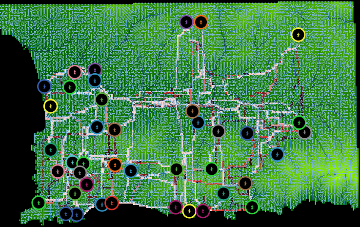
View of MesaraTrade after set up
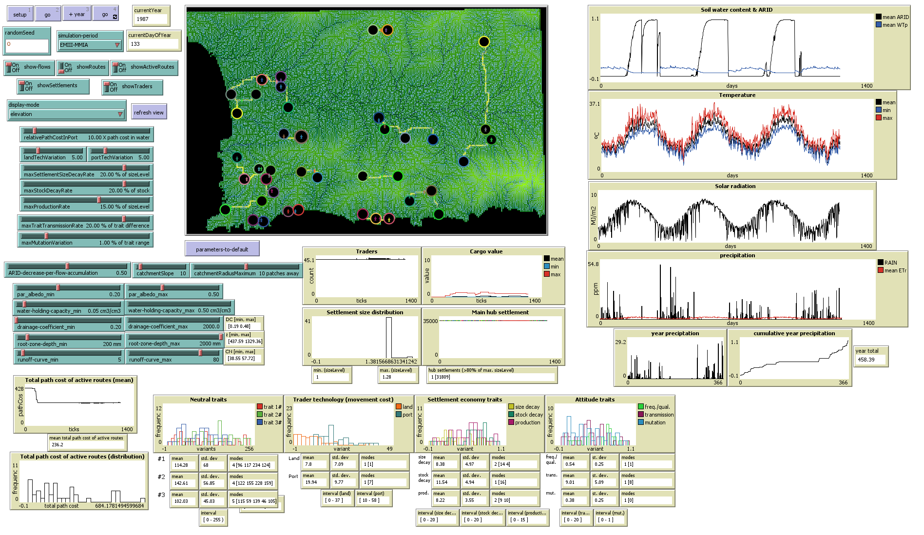
View of MesaraTrade interface
21.4 Margins to improve and explore
There are many other points to refactor, explore alternatives and expand. Just remember to first give it a think and then start writing code.
For example:
- Can we visualise catchmentArea of settlements in the NetLogo View, instead of sizeLevel? - Could we find a way to calibrate the speed of traders to the same daily rhythm of the weather variables?
- Could rivers also affect patchCost?