27 Calculating ARID
Let us build the next module, ARID, over what we just implemented in the load-weather-data module.
27.1 Module variables and parameters
Besides the weather variables we have on our dataset, ARID requires several other variables related to soil properties and cover. We will make an exception to our code legibility rule and use the notation from the original implementation (Wallach et al. 2019).
Notice that we are also introducing one way of dealing with multiple approaches to parameter setting. We create a chooser named experiment-type in the interface and use it to activate one of two approaches: “user-defined”, which takes the values of sliders in the interface, and “random”, which samples these values randomly within a predetermined range. We also introduce two useful procedures, parameters-check and parameters-to-default, to help us define and return to an specific “default” parameter configuration used as a point of reference.
globals
[
  ...

  ;;; default constants

  MUF ; Water Uptake coefficient (mm^3.mm^-3)
  WP ; Water content at wilting Point (cm^3.cm^-3)

  ;;;; ETr
  albedo_min
  albedo_max

  ;;;; Soil Water Balance model global parameters
  WHC_min
  WHC_max
  DC_min
  DC_max
  z_min
  z_max
  CN_min
  CN_max

  ...
]

...

patches-own
[
  ...

  ;;;; soil
  DC ; Drainage coefficient (mm^3 mm^-3).
  z ; root zone depth (mm).
  CN ; Runoff curve number.
  FC ; Water content at field capacity (cm^3.cm^-3)
  WHC ; Water Holding Capacity of the soil (cm^3.cm^-3). Typical range from 0.05 to 0.25

  ARID ; ARID index after Woli et al. 2012, ranging form 0 (no water shortage) to 1 (extreme water shortage)
  WAT ; Water content in the soil profile for the rooting depth (mm)
  WATp ; Volumetric Soil Water content (fraction : mm.mm-1). calculated as WAT/z

  ;;;; cover
  albedo ; canopy reflection or albedo
  netSolarRadiation ; net solar radiation discount canopy reflection or albedo
  ETr ; reference evapotranspiration
]
27.2 Setting module parameters
We will use a randomised configuration of most of these patch variables using hyperparameters giving the envelope of variation. The Indus Village eventually escapes this initial solution by calculating these variables based on various datasets and submodels. We will, however, use it for the sake of simplicity. As Wallach et al. (2019), we will use two global variables as constants (MUF and WP) and create some extra procedures that will help us register and apply a default configuration of the hyperparameters (parameters-check and parameters-to-default).
to set-constants

  ; "constants" are variables that will not be explored as parameters
  ; and may be used during a simulation.

  ; MUF : Water Uptake coefficient (mm^3 mm^-3)
  set MUF 0.096

  ; WP : Water content at wilting Point (cm^3.cm^-3)
  set WP 0.06

end

to set-parameters

  ; set random seed
  random-seed seed

  ;;; load weather input data from file
  load-weather-input-data-table

  parameters-check

  ;;; weather parameters are left with default values, but effectively ignored given that input weather is used.

  set albedo_min 1E-6 + random-float 0.3
  set albedo_max albedo_min + random-float 0.3

  if (experiment-type = "user-defined")
  [
    set albedo_min par_albedo_min
    set albedo_max par_albedo_max

    ;;; Soil Water Balance model
    set WHC_min water-holding-capacity_min
    set WHC_max water-holding-capacity_max
    set DC_min drainage-coefficient_min
    set DC_max drainage-coefficient_max
    set z_min root-zone-depth_min
    set z_max root-zone-depth_max
    set CN_min runoff-curve_min
    set CN_max runoff-curve_max
  ]
  if (experiment-type = "random")
  [
    set albedo_min 1E-6 + random-float 0.3
    set albedo_max albedo_min + random-float 0.3

    ;;; Soil Water Balance model
    set WHC_min random-float 0.1
    set WHC_max WHC_min + random-float 0.1
    set DC_min 1E-6 + random-float 0.45
    set DC_max DC_min + random-float 0.45
    set z_min random-float 1000
    set z_max z_min + random-float 1000
    set CN_min random-float 40
    set CN_max CN_min + random-float 50
  ]

end

to parameters-check

  ;;; check if values were reset to 0 (NetLogo does that from time to time...!)
  ;;; and set default values (assuming they are not 0)

  if (par_albedo_min = 0)                                        [ set par_albedo_min                              0.1 ]
  if (par_albedo_max = 0)                                        [ set par_albedo_max                              0.5 ]

  if (water-holding-capacity_min = 0)                            [ set water-holding-capacity_min                    0.05 ]
  if (water-holding-capacity_max = 0)                            [ set water-holding-capacity_max                    0.25 ]
  if (drainage-coefficient_min = 0)                              [ set drainage-coefficient_min                      0.3 ]
  if (drainage-coefficient_max = 0)                              [ set drainage-coefficient_max                      0.7 ]
  if (root-zone-depth_min = 0)                                   [ set root-zone-depth_min                         200 ]
  if (root-zone-depth_max = 0)                                   [ set root-zone-depth_max                        2000 ]
  if (runoff-curve_min = 0)                                      [ set runoff-curve_min                             30 ]
  if (runoff-curve_max = 0)                                      [ set runoff-curve_max                             80 ]

end

to parameters-to-default

  ;;; set parameters to a default value
  set par_albedo_min                                            0.1
  set par_albedo_max                                            0.5

  set water-holding-capacity_min                                0.05
  set water-holding-capacity_max                                0.25
  set drainage-coefficient_min                                  0.3
  set drainage-coefficient_max                                  0.7
  set root-zone-depth_min                                     200
  set root-zone-depth_max                                    2000
  set runoff-curve_min                                         30
  set runoff-curve_max                                         80

end

...

to setup-soil-water-properties

  ask patchesWithElevationData
  [
    set albedo albedo_min + random-float (albedo_max - albedo_min)

    ; Water Holding Capacity of the soil (cm^3 cm^-3).
    set WHC WHC_min + random-float (WHC_max - WHC_min)
    ; DC :  Drainage coefficient (mm^3 mm^-3)
    set DC DC_min + random-float (DC_max - DC_min)
    ; z : root zone depth (mm)
    set z z_min + random (z_max - z_min)
    ; CN : Runoff curve number
    set CN CN_min + random (CN_max - CN_max)

    ; FC : Water content at field capacity (cm^3.cm^-3)
    set FC WP + WHC
    ; WAT0 : Initial Water content (mm)
    set WAT z * FC
  ]

end
27.3 Calculating Reference Evapotranspiration (ETr)
In our previous implementation of set-day-weather-from-input-data, we must now add a new final step, where netSolarRadiation and ETr (reference evapotranspiration) are set for each patch. We also need to implement a procedure to estimate ETr based on an FAO standard (Allen et al. 1998).
Allen, Richard G., Luis S. Pereira, Dirk Raes, and Martin Smith. 1998. Crop Evapotranspiration - FAO Irrigation and Drainage Paper No. 56. Rome: FAO. http://www.fao.org/3/X0490E/x0490e00.htm.
to set-day-weather-from-input-data [ dayOfYear year ]

  ...

  ask patchesWithElevationData
  [
    set netSolarRadiation (1 - albedo) * solarRadiation
    set ETr get-ETr
  ]

end

...

to-report get-ETr

  ;;; useful references:
  ;;; Suleiman A A and Hoogenboom G 2007
  ;;; Comparison of Priestley-Taylor and FAO-56 Penman-Monteith for Daily Reference Evapotranspiration Estimation in Georgia
  ;;; J. Irrig. Drain. Eng. 133 175–82 Online: http://ascelibrary.org/doi/10.1061/%28ASCE%290733-9437%282007%29133%3A2%28175%29
  ;;; also: Jia et al. 2013 - doi:10.4172/2168-9768.1000112
  ;;; Allen, R. G., Pereira, L. A., Raes, D., and Smith, M. 1998.
  ;;; “Crop evapotranspiration.”FAO irrigation and  drainage paper 56, FAO, Rome.
  ;;; also: http://www.fao.org/3/X0490E/x0490e07.htm
  ;;; constants found in: http://www.fao.org/3/X0490E/x0490e07.htm
  ;;; see also r package: Evapotranspiration (consult source code)

  let windSpeed 2 ; as recommended by: http://www.fao.org/3/X0490E/x0490e07.htm#estimating%20missing%20climatic%20data

  ;;; estimation of saturated vapour pressure (e_s) and actual vapour pressure (e_a)
  let e_s (get-vapour-pressure T_max + get-vapour-pressure T_min) / 2
  let e_a get-vapour-pressure T_min
  ; ... in absence of dew point temperature, as recommended by
  ; http://www.fao.org/3/X0490E/x0490e07.htm#estimating%20missing%20climatic%20data
  ; however, possibly min temp > dew temp under arid conditions

  ;;; slope of  the  vapor  pressure-temperature  curve (kPa ºC−1)
  let DELTA 4098 * (get-vapour-pressure T) / (T + 237.3) ^ 2

  ;;; latent heat of vaporisation = 2.45 MJ.kg^-1
  let lambda 2.45

  ;;; specific heat at constant pressure, 1.013 10-3 [MJ kg-1 °C-1]
  let c_p 1.013 * 10 ^ -3
  ;;; ratio molecular weight of water vapour/dry air
  let epsilon 0.622
  ;;; atmospheric pressure (kPa)
  let P 101.3 * ((293 - 0.0065 * elevation) / 293) ^ 5.26
  ;;; psychometric constant (kPa ºC−1)
  let gamma c_p * P / (epsilon * lambda)

  ;;; Penman-Monteith equation from: fao.org/3/X0490E/x0490e0 ; and from: weap21.org/WebHelp/Mabia_Alg ETRef.htm

  ; 900 and 0.34 for the grass reference; 1600 and 0.38 for the alfalfa reference
  let C_n 900
  let C_d 0.34

  let ETr_temp (0.408 * DELTA * netSolarRadiation + gamma * (C_n / (T + 273)) * windSpeed * (e_s - e_a)) / (DELTA + gamma * (1 + C_d * windSpeed))

  report ETr_temp

end

to-report get-vapour-pressure [ temp ]

  report (0.6108 * exp(17.27 * temp / (temp + 237.3)))

end
27.4 Implementing the main algorithm
Next, we add update-WAT, which contains the calculations that finally outputs ARID.
to update-WAT

  ; Soil Water Balance model
  ; Using the approach of:
  ; 'Working with dynamic crop models: Methods, tools, and examples for agriculture and enviromnent'
  ;  Daniel Wallach, David Makowski, James W. Jones, François Brun (2006, 2014, 2019)
  ;  Model description in p. 24-28, R code example in p. 138-144.
  ;  see also https://github.com/cran/ZeBook/blob/master/R/watbal.model.r
  ; Some additional info about run off at: https://engineering.purdue.edu/mapserve/LTHIA7/documentation/scs.htm
  ; and at: https://en.wikipedia.org/wiki/Runoff_curve_number

  ; Maximum abstraction (mm; for run off)
  let S 25400 / CN - 254
  ; Initial Abstraction (mm; for run off)
  let IA 0.2 * S
  ; WATfc : Maximum Water content at field capacity (mm)
  let WATfc FC * z
  ; WATwp : Water content at wilting Point (mm)
  let WATwp WP * z

  ; Change in Water Before Drainage (Precipitation - Runoff)
  let RO 0
  if (RAIN > IA)
  [ set RO ((RAIN - 0.2 * S) ^ 2) / (RAIN + 0.8 * S) ]
  ; Calculating the amount of deep drainage
  let DR 0
  if (WAT + RAIN - RO > WATfc)
  [ set DR DC * (WAT + RAIN - RO - WATfc) ]

  ; Calculate rate of change of state variable WAT
  ; Compute maximum water uptake by plant roots on a day, RWUM
  let RWUM MUF * (WAT + RAIN - RO - DR - WATwp)
  ; Calculate the amount of water lost through transpiration (TR)
  let TR min (list RWUM ETr)

  let dWAT RAIN - RO - DR - TR
  set WAT WAT + dWAT

  set WATp WAT / z

  set ARID 0
  if (TR < ETr)
  [ set ARID 1 - TR / ETr ]

end
27.5 Merging with spatial data module
Until this point, we are still lacking our spatial data. Let us implement the necessary code to be able to import the processed data we output from the flows module.
extensions [ csv gis ]

...

breed [ sites site ]

breed [ flowHolders flowHolder ]

...

globals
[
  patchesWithElevationData
  noElevationDataTag
  maxElevation

  width
  height

  ;;; GIS data holders
  sitesData_EMIII-MMIA
  sitesData_MMIB
  elevationData
  riversData

  ...
]

sites-own
[
  name
  siteType
  period
]

patches-own
[
  elevation ; elevation above sea level [m]

  flow_direction        ; the numeric code for the (main) direction of flow or
                        ; drainage within the land unit.
                        ; Following Jenson & Domingue (1988) convention:
                        ; NW = 64,   N = 128,        NE = 1,
                        ; W = 32,     <CENTRE>,   E = 2,
                        ; SW = 16,     S = 8,          SE = 4

  flow_receive          ; Boolean variable stating whether or not the land unit receives
                        ; the flow of a neighbour.

  flow_accumulation     ; the amount of flow units accumulated in the land unit.
                        ; A Flow unit is the volume of runoff water flowing from one land unit
                        ; to another (assumed constant and without losses).
  flow_accumulationState ; the state of the land unit regarding the calculation of flow
                        ; accumulation (auxiliary variable).

  isRiver

  ...
]

...


to import-map-with-flows

  import-world "data/terrainWithFlows/BlockC_module2_flows world.csv"

  ;;; reduce patch size in pixels
  set-patch-size 3

end

...
27.6 Visualisation
Before advancing, we can implement a display procedure expanding it also to be able to paint patches according to the new patch variables, using the “chooser” parameter display-mode:
to refresh-view

  if (display-mode = "elevation")
  [
    ask patchesWithElevationData [ display-elevation ]
  ]

  if (display-mode = "albedo")
  [
    ask patchesWithElevationData [ display-albedo ]
  ]

  if (display-mode = "ETr")
  [
    let maxETr max [ETr] of patchesWithElevationData
    ask patchesWithElevationData [ display-ETr maxETr ]
  ]

  if (display-mode = "drainage coefficient (DC)")
  [
    ask patchesWithElevationData [ display-DC ]
  ]

  if (display-mode = "root zone depth (z)")
  [
    let maxZ max [z] of patchesWithElevationData
    ask patchesWithElevationData [ display-z maxZ ]
  ]

  if (display-mode = "runoff curve number (CN)")
  [
    let maxCN max [CN] of patchesWithElevationData
    ask patchesWithElevationData [ display-CN maxCN ]
  ]

  if (display-mode = "water content at field capacity (FC)")
  [
    let maxFC max [FC] of patchesWithElevationData
    ask patchesWithElevationData [ display-FC maxFC ]
  ]

  if (display-mode = "water holding Capacity (WHC)")
  [
    let maxWHC max [WHC] of patchesWithElevationData
    ask patchesWithElevationData [ display-WHC maxWHC ]
  ]

  if (display-mode = "soil water content (WATp)")
  [
    let maxWATp max [WATp] of patchesWithElevationData
    ask patchesWithElevationData [ display-WATp maxWATp ]
  ]

  if (display-mode = "ARID coefficient")
  [
    ask patchesWithElevationData [ display-arid ]
  ]

end

to display-elevation

  let elevationGradient 100 + (155 * (elevation / maxElevation))
  set pcolor rgb (elevationGradient - 100) elevationGradient 0

end

to display-albedo

  set pcolor 1 + 9 * albedo

end

to display-ETr [ maxETr ]

  ifelse (maxETr = 0)
  [ set pcolor 25 ]
  [ set pcolor 22 + 6 * (1 - ETr / maxETr) ]

end

to display-DC

  set pcolor 112 + 6 * (1 - DC)

end

to display-z [ maxZ ]

  set pcolor 42 + 8 * (1 - z / maxZ)

end

to display-CN [ maxCN ]

  set pcolor 72 + 6 * (1 - CN / maxCN)

end

to display-FC [ maxFC ]

  set pcolor 82 + 6 * (1 - FC / maxFC)

end

to display-WHC [ maxWHC ]

  set pcolor 92 + 6 * (1 - WHC / maxWHC)

end

to display-WATp [ maxWATp ]

  set pcolor 102 + 6 * (1 - WATp / maxWATp)

end

to display-ARID

  set pcolor 12 + 6 * ARID

end
27.7 Combining with flow accumulation algorithm
Last, we finalise this module by implementing a solution that uses flow_accumulation to modulate the variation in ARID, as a proxy of the effect of the regional hydrology on the local soil water balance. The solution use the patch variable ARID_modifier, set during setup according to the parameter ARID-decrease-per-flow-accumulation and the local relative flow accumulation (flow_accumulation / maxFlowAccumulation). It then modifies ARID each day as a simple scalar.
patches-own
[
  ...

  ARID_modifier ; modifier coefficient based on the relative value of flow_accumulation
]

...

to setup

  clear-all

  ; --- loading/testing parameters -----------

  import-map-with-flows ; import-world must be the first step

  set-constants

  set-parameters

  setup-patches

  ; --- core procedures ----------------------

  set currentYear weatherInputData_firstYear
  set currentDayOfYear 1

  ;;; values are taken from input data
  set-day-weather-from-input-data currentDayOfYear currentYear

  ask patchesWithElevationData [ update-WAT ]

  ; --- display & output handling ------------------------

  refresh-view

  ; -- time -------------------------------------

  reset-ticks

end

...

to setup-patches

  setup-soil-water-properties

  setup-ARID-modifier

end

...

to setup-ARID-modifier

  ask patchesWithElevationData
  [
    set ARID_modifier (1 - ARID-decrease-per-flow-accumulation * (flow_accumulation / maxFlowAccumulation))
  ]

end

...

to go

  ; --- core procedures -------------------------

  ;;; values are taken from input data
  set-day-weather-from-input-data currentDayOfYear currentYear

  ask patchesWithElevationData [ update-WAT modify-ARID ]

  ; --- output handling ------------------------

  refresh-view

  ; -- time -------------------------------------

  advance-time

  tick

  ; --- stop conditions -------------------------

  if (currentYear = weatherInputData_lastYear and currentDayOfYear = last weatherInputData_yearLengthInDays) [stop]

end

...

to modify-ARID

  set ARID ARID * ARID_modifier

end
27.8 Checking the milestone File (module 4)
Our solution to link flow_accumulation and ARID is undoubtedly arbitrary. Such solutions should always be temporary and prompt further research and coding excursions. For the tutorial, however, we are good enough to go forward.
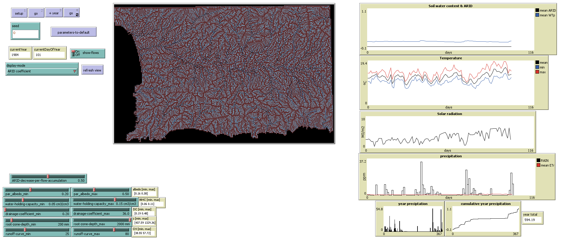
Screenshot of the ‘ARID’ module (tick 100)
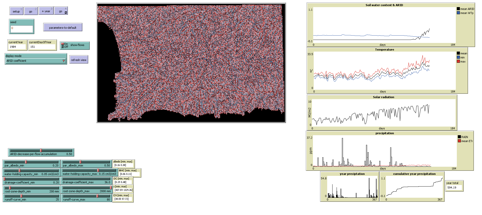
Screenshot of the ‘ARID’ module (tick 150)
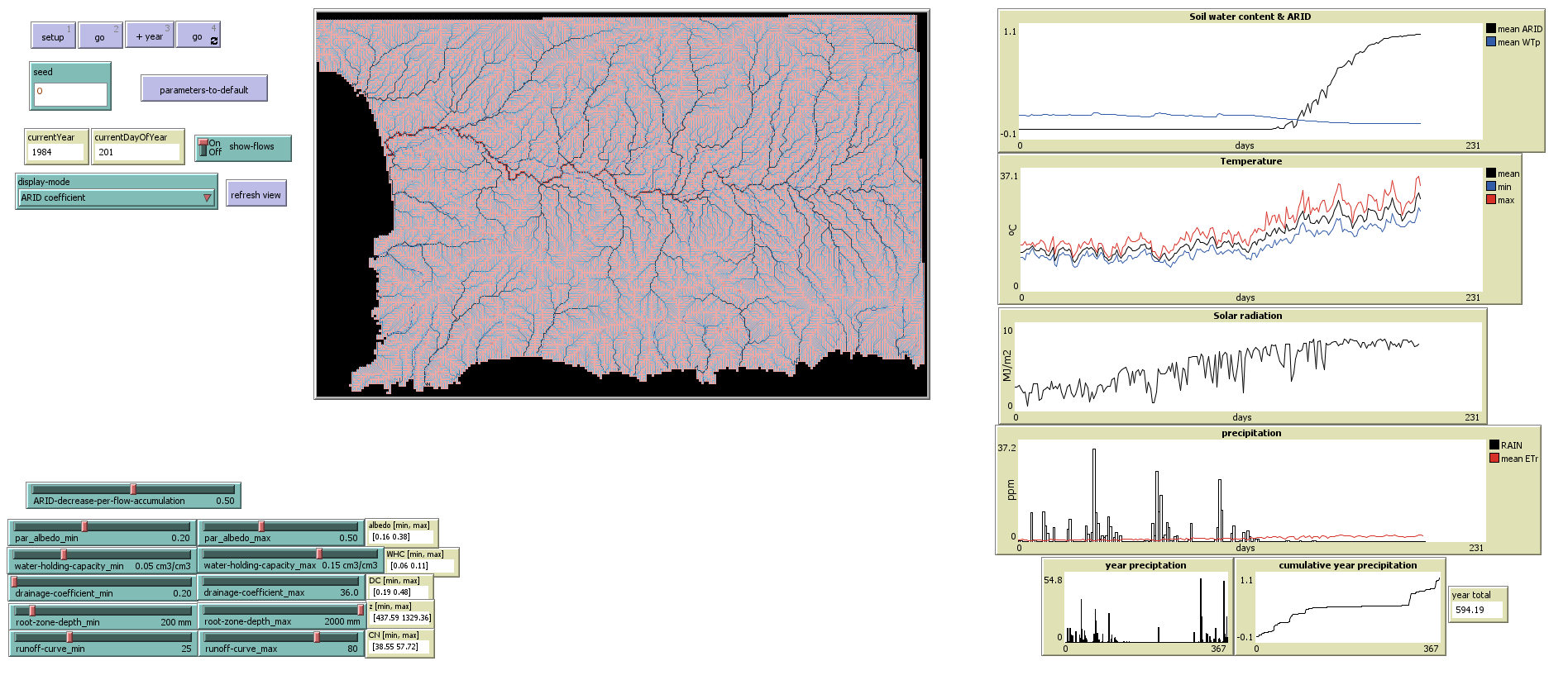
Screenshot of the ‘ARID’ module (tick 200)
See the fully implemented version of this module: BlockC_module3_ARID.nlogo.