28 Scaling up route calculation
Before finally implementing a grounded productivity in Pond Trade, we must stop and consider the consequences of applying A* to a quite different terrain.
First and most obviously, unlike our initial “pond” terrain, the GIS data we are using has no water patches and land patches have different elevation values. We went from having a binary height map (land/water) to a continuous height map strictly covering dry land.
28.1 Adapting A* to use a path cost gradient
We adapt the original implementation of assign-path-cost to handle elevation values in a more refined way. We will use a simple approach that equates the path cost in a patch to the standard deviation of the elevation of all neighbours and of itself. This gives the algorithm a rough notion of terrain roughness, awarding those plain sectors of terrain with the least path cost for routes.
to assign-path-cost

  ask patches with [elevation = noElevationDataTag] [ set pathCost 9999 ] ;;; this makes routes crossing patches with no elevation data extremely unlikely

  ask patchesWithElevationData
  [
    let myValidNeighborsAndI (patch-set self (neighbors with [elevation > noElevationDataTag]))

    ifelse (count myValidNeighborsAndI > 1)
    [
      set pathCost standard-deviation [elevation] of myValidNeighborsAndI
    ]
    [
      set pathCost 1
    ]
  ]

end
Another, possibly more rigorous, solution would be to precalculate routes from a least path cost analysis using specialised GIS software and import it as a GIS dataset.
28.2 Implementing file export-import procedures: a solution to handle a larger grid
With the large size of the map and the higher number of settlements, we expect A* calculation of routes to take significant computation time. For this reason, we are highly motivated to make of route calculation the subject of a module, which is able to export the variable routes to a file that can be stored and imported later.
As we are already using export-world to save our height map with flows, we implement procedures that can manage the export and import of the routes variable specifically.
to export-routes-to-file

  ;;; build a unique file name to identify current setting
  let filePath (word "data/routes/routes_" simulation-period "_w=" world-width "_h=" world-height "_randomSeed=" randomSeed ".txt")

  file-open filePath

  foreach routes
  [
    aRoute ->

    file-print aRoute
  ]

  file-close

end

to import-routes-from-file

  ;;; get unique file name corresponding to the current setting
  let filePath (word "data/routes/routes_" simulation-period "_w=" world-width "_h=" world-height "_randomSeed=0.txt")

  ifelse (not file-exists? filePath)
  [ print (word "WARNING: could not find '" filePath "'") stop ] ;;; unfortunately the stop command doesn't stop the setup procedure
  [
    file-open filePath

    set routes []

    while [not file-at-end?]
    [
      let lineString file-read-line
      set lineString remove-item 0 lineString
      set lineString remove-item (length lineString - 1) lineString
      set lineString (word "(list " lineString " )")

      set routes lput (run-result lineString) routes
    ]
  ]

  file-close

end
28.3 Run and export routes
If you wish to test this step, you may now execute setup and export-routes-to-file using the sites of each period (simulation-period). Because the routes file is already present in the repository, a test must be executed with import-routes switched off. Beware, the process can take hours. If you started the process and want to stop it, go to “Tools > Halt”.
Alternatively, you may simply execute setup with import-routes switched on, and visualise the routes calculated for each pair of sites in each period. This should take around 1-2 minutes.
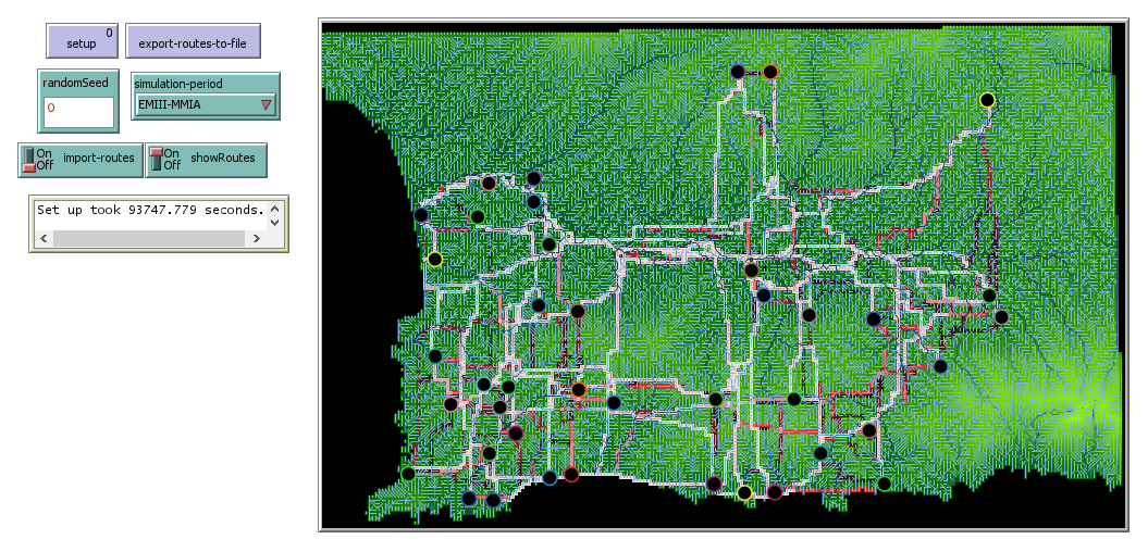
Screenshot of the ‘routes’ module displaying routes between EMIII-MMIA sites
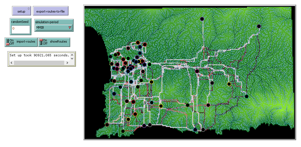
Screenshot of the ‘routes’ module displaying routes between MMIB sites
Relying on the tint of routes, we can immediately see that most paths are used by more than one route (bright red), which could be hinting a relatively stable road structure. A more interesting, but less obvious insight is that
28.4 Pause for interpretation
Note that the routes calculated with our implementation of A* generally agrees with Paliou and Bevan (Paliou and Bevan 2016) analysis using other techniques. Routes are distinctively different between periods, with a minimal overlap during the Prepalatial (EMIII-MMIA) period and the Protopalatial (MMIB) period marked with a much higher centrality in the lower valley, where Phaistos is located.
However, do remember that this result is obtained only by combining elevation and site distributions using a least path cost algorithm. A* is a procedural algorithm, which contains explicative elements, but is not a simulation in the strict sense (i.e. the aim is finding an optimal path, not the representation of real instance of path walking). We are yet to observe what effects the Pond Trade mechanism have over the economical size of each site, given the routes available in each period.